How to Change Google maps view
There are different types of views available on Google maps and we should know how to change the Google Maps view.
There are various views such as terrain view, street view, and satellite view among others. These different views are for different locations and purposes. The normal view of Google Maps is known as the default view. Keep the knowledge of all these views to use Google Maps properly. Now, let's read the article below to know how to change the Google Maps view.
How to change Google Maps Satellite View
Change Google maps view in 3 Steps
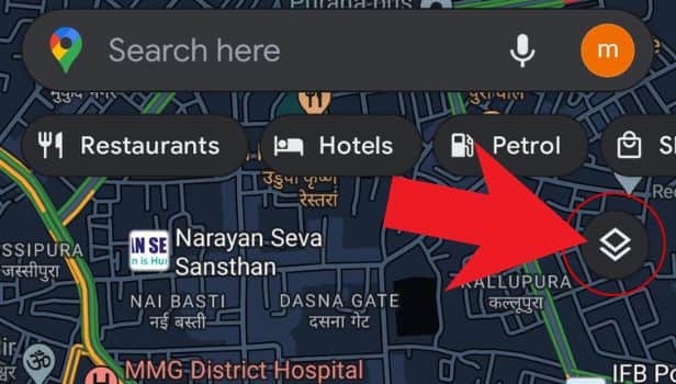
Step-1 Open Google maps: You first have to simply open the Google Maps application on your device.
If you are using your desktop, then you have to open it with the help of your web browser.

Step-2 Click on the icon as shown: Then, in the second step, you have to click on the icon on the map that is present below the search bar on the right-hand side.
You can see the picture below for reference.
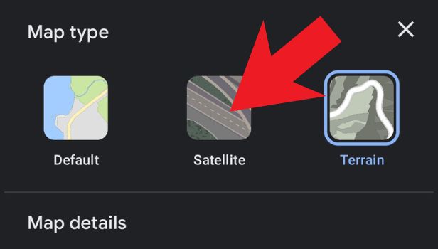
Step-3 Choose the map type: the third and final step is to choose a view from the list of options available to you.
These all are the different kinds of views in Google Maps.
FAQ
What Are The Different Types Of Views on Google Maps?
There are basically four types of use available on Google Maps.
These four types of views are as follows:
- Default view- It is the default view of the Google Maps application which shows everything on the map.
- Satellite view
- Terrain View
- Street View
Is It Possible To Avoid Tolls With The help of Google Maps Views?
It is very easy to avoid tolls on Google Maps using specific views.
You can do it in the following steps:
- Open the app.
- Click on the search bar.
- Find the exact location on the map.
- Tap on the location and tap ‘directions’.
- Enter your current location or starting point.
- Then, click on the three bars icon.
- Now, tap on ‘route options’.
- Choose ‘avoid tolls’.
Now, Google maps will show you the route without tolls.
What is the use of Street View on Google Maps?
The street view of the Google Maps app can be very helpful in many cases.
You can easily use Google Street view when you have to find directions in a very congested area. It makes finding your destination very convenient and hassle-free. It can also be used in residential areas to find the house of your relatives. You can find a particular and even though smallest location on Google Street view.
What Is The Satellite View in Google Maps and How Is It Helpful?
The satellite view is a very advanced concept that was enabled by Google some time back in Google Maps.
It basically enables you to get a clear realistic and high-quality satellite images of various locations on the map. Also, you can use the satellite map type to check how a particular site looks in real life. It can help a lot when selecting someplace which you have never seen before and get an image overview of that specific place or that area.